Friday, April 19, 2024


The Washington redistricting commission failed to submit revised Legislative and Congressional District maps on their Nov. 15 deadline. Ultimately, the final decision will be up to the State Supreme Court on April 30, 2022.
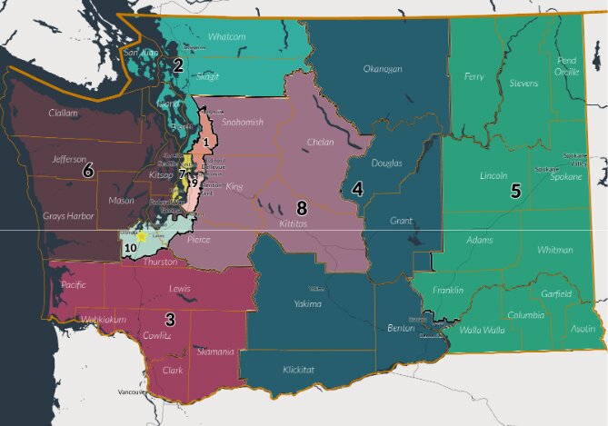
The Bipartisan Redistricting Commission meets once every 10 years to redraw district boundaries ever since the 1990 census. They are to approve boudary lines for 10 congressional districts and 49 legislative districts. The commission consists of two democratic members and two republican members to ensure a bipartisan map. This is the first time that a Washington State nonpartisan board has missed the Nov. 15 deadline and was sent to the court.
According to the Spokesman Review, the Commission seemed to have initially made a vote on the maps before the midnight deadline. However, a statement was released on Nov. 16 that they had missed the deadline, legally requiring them to hand over the decision to the State Supreme Court. The Monday meeting was also held in private, which may have violated the Open Public Meetings Act.
Aside from these issues, the Commission was also met hefty criticisms from both Democratic and Republican stakeholders, who find that the proposed map unnecessarily divides Chelan, Okanogan, and Douglas counties.
12th District Senator Brad Hawkins (R) feels uncertain about the process going.
"No one really knows because this is kind of the first time that our bipartisan redistricting commission process went kinda sideways."
Hawkins claimed that the 2020 census found that western washington had increased in population and eastern washington had "underperformed," resulting in the need to balance the districts.
"Some of the legislative districts east of the 12th districts needed to grow geographically and expand, pick up population," Sen. Hawkins explained. "That had the effect of nudging over a district like the 12th that is on the border of the Cascade mountain."
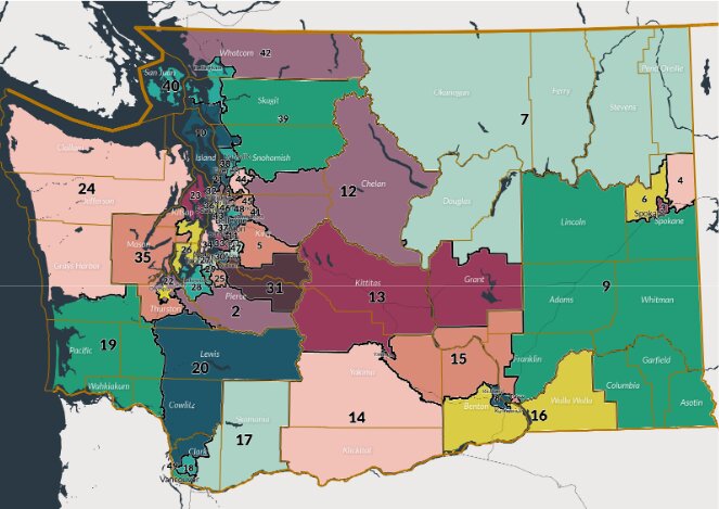
Sen. Hawkins was left disappointed by the proposed Legislative District Map, which will now be split away from Okanogan and Douglas regions. The district will be combined with western regions spanning all the way to Monroe and upper valley regions just below the Methow river.
"Traditionally, the 12th district has always been a north central Washington-based district. Chelan County, Douglas County, and part of Okanogan and some of Grant," Sen. Hawkins explained. "Well now this shifts it over but the map that's proposed includes all of Chelan County and a good portion of East Wenatchee, but the remaining amounts of Douglas County are proposed to be in another district."
Many organizations such as the Chelan-Douglas Transportation Council, the Wenatchee Valley Chamber of Commerce, the Methow Valley Citizens Council Action Fund, and Chelan County Board of Commissioners have voiced their own concerns to the Redistricting Commission regarding possible seperation from Chelan and Douglas regions.
"The map doesn't in any way reflect what the commission received in public comment and that's disappointing," Sen. Hawkins said. "North Central Washington has a long, proud history of cooperative work across the two counties."
2020 Democratic candidate for 12th District State Representative Adrianne Moore shares Sen. Hawkins disappointment over the proposed maps.
"I know it makes the district slightly more competitive, but I think at the loss of keeping the communities together," Moore said.
Moore notes her own disappointment for how divided the map looks politically, especially in a supposedly nonpartisan redistricting process.
"I think one of the most disappointing things I heard in the press conference following the release of the maps was that there's basically been a trade where Republicans got to draw Eastern Washington and the democratic commissioners got to draw Western Washington," Moore said.
"I think that really violates the spirit of a bipartisan commission in which politics should stay out of electoral politics, that we should stay out of districting/redistricting process."
One of the goals of the Commission was to keep the Yakama Nation intact and to retain what they call a minority/majority district in Yakima. The Commission hopes to elevate the voting representation of People of Color (POC) in each district by drawing regions that are balanced in POC populace.
According to Crosscut, many have criticized this decision as inconsistent with the Voting Rights Act, failing to figure in the population of the voting-age latino population rather than the total latino population in Yakima. Republicans also raised questions as to whether racially-motivated districting decisions violate the Equal Protection Act.
Moore feels that the new map does agree with the Commission's own goals. "It didn't seem like it met those criteria and some of the information that has come out afterwards around the Yakima valley region seems to point to not meeting both the recommendations or the hope of having, districts of minority/majority districts and building better cohesion for tribal communities."
Moore added that the Colville Confederated tribe had advocated for their districts not to change and that they were okay with the split.
The State Supreme Court has three options. They can either approve the final map that redistricting commissioners tried to finalize; make adjustment to that proposed map; or open the process up for public comments and start all over again.
"I think not being able to develop communities that were in the best interest of the people rather than in the best interests of the parties is a loss for all of us," Moore concluded. "I think we could and should do better."


Comments
No comments on this item Please log in to comment by clicking here